Graduate Research Fellows 2003

Joan Blainey

Joan Blainey, co-sponsored by the University of Arizona Department of Hydrology and Water Resources

I believe the best way to create a greater public understanding of science is to engage the next generation of Americans at the primary and secondary school level in scientific exploration of the natural world. As a Space Grant Fellow, my goal is to improve scientific literacy in earth system science by developing soil moisture educational materials for the web, and by participating in GLOBE soil moisture data collection campaigns with southern Arizona students. GLOBE, a global science outreach program of cooperative schools, has so far linked soil moisture data collection campaigns for 200 K-12 schools. From January 1998 to the present, 12,000 schools around the world have been trained in GLOBE protocols which include data collection for air temperature, surface water quality, soil moisture, and/or soil temperature. GLOBE is a worldwide hands-on primary and secondary school-based science program that provides students the opportunity to take scientific measurements, report their data on the internet, and utilize the interactive website (www.globe.gov) to create maps and graphs of GLOBE data sets. As my primary contribution to educational outreach, I will develop and conduct classroom testing of age-appropriate GLOBE educational materials that help students and teachers understand scientific fundamentals such as hypothesis testing, data sampling, and data analysis in addition to a basic introduction to earth science via the hydrologic cycle.

Soil moisture is an important component of the hydrologic cycle. Only a very small portion of the earth’s fresh water is held in soil, but it is a critical resource for plant and animal life. The availability of soil moisture at any given time or place plays an important role in the exchange of moisture and energy between the atmosphere and the land surface. Soil moisture directly affects the partitioning of incoming solar radiation into sensible and latent heat fluxes, affects soil thermal properties as well as surface albedo, and is a controlling variable affecting the distribution of plant assemblages. Knowledge of soil moisture is essential for predicting climate on annual and seasonal time scales.

Many studies have demonstrated that passive microwave remote sensing has great potential for monitoring soil moisture on a large scale. In the upper 5 cm of the earth’s surface, microwave frequencies detect a large difference in the emission between water and dry soil due to the dielectric constant of water. Measurements obtained from passive microwave instruments are calibrated by comparison with ground-based measurements. Ground-based measurements are critical for verification and improved interpretation of measurements obtained by passive microwave sensors.

Gravimetric soil moisture measurements, the current scientific standard for measuring soil moisture, can be made simply and reliably with minimal equipment needs. By engaging K-12 students in soil moisture data collection and gravimetric soil moisture measurements throughout the United States, a scientific data set will be created that will provide researchers with much needed information about the spatial distribution of soil moisture. Because of the great cost and logistical challenges, few large-scale field experiments have been conducted in which soil moisture measurements have been made simultaneously or near-simultaneously over large areas. A goal of the GLOBE soil moisture program is to recruit as many students and schools as possible to provide such a dataset.

At the middle and high school level, student activities include collecting soil moisture samples and measuring soil moisture following GLOBE protocols. In accordance with these protocols, teams of students, parents, and local mentors select an open flat area of about 90 m by 90 m within 10 km of their school. Three samples of soil moisture are collected twice each year at depths of 0 to 5 cm and at 10 cm within a 10 m circle and are identified by GPS coordinates. Students at the high school level determine the mass of the soil samples both wet and after oven drying to determine gravimetric water content and bulk density.

In coordination with local educational outreach associated with these sampling activities, I propose to develop and conduct classroom testing of a series of age-appropriate lesson plans for K-12 teachers to help students make connections between point, local, and regional soil moisture measurements. These materials will be made available to teachers on the GLOBE web site (www.globe.gov).

By determining the months of the year during which the largest portion of the earth’s landmass has soil moisture values above a particular threshold, we can determine the best time for GLOBE students to engage in their data collection campaigns. Soil moisture measurements are typically within a small range of values; the timing of soil moisture campaigns is of primary importance in order to incorporate a range of values when sampling efforts occur only twice a year. The second valuable component of the students’ data will be an analysis of the spatial variability in measured soil moisture, which will be compared with existing predictions of spatially distributed soil moisture derived from land surface models and satellite-based remote sensing.

Engaging students with data collection, experimentation, and classroom activities related to the soil moisture component of the hydrologic cycle, an aspect of earth science with which they have some familiarity, will provide an exciting challenge. My contribution is to test and provide teachers with prepared materials and activities as a basis for their lesson plans and to make these materials available on the GLOBE website. During the fall, I have been contacting local teachers involved in previous years with the GLOBE soil moisture campaign to get their input on the educational materials I have been developing and to begin developing a connection with the Tucson teachers and schools I will collaborate with during the April soil moisture sampling campaign. I hope the impact of these activities will be to strengthen the basic understanding of an earth science topic in schools participating in GLOBE and to provide more Internet resources for teachers to present earth science curricula.

Michael Crimmins

Michael Crimmins, co-sponsored by the University of Arizona Department of Geography and Regional Development

Academic scientists have the unique opportunity to participate in public science education through their research activities. Applied research projects have the ability to produce working relationships and lines of communication between public users and scientists that are often difficult to forge. These lines of communication allow for exchanges of knowledge between the public and the academic scientist. Public users of scientific research can communicate their needs for new research based products, while scientists can convey basic scientific principles that improve the literacy of user. A feedback of scientific communication can be initiated by academic scientists interested in reaching out to the public for which they are working. Greater scientific literacy will inevitably lead to a greater public hunger for academic research.

I have the opportunity to participate in science outreach and education through my research activities on the relationships between climate variability and wildfire risk. Recent research has proven that inter-annual climate variability modulates the fire regimes of many forest ecosystems in the desert southwest (Swetnam and Betancourt 1998). The subtleties of this wildfire-climate connection are not completely understood, for either forest or grassland ecosystems, and will be the subject of my doctoral research activities.

I believe that this research will have direct and immediate relevance to natural resource and rangeland managers. I have discussed this research topic with Kim McReynolds, University of Arizona Natural Resources Extension Agent, and she believes there is a need to communicate climate information to her constituents and to help educate them on the connections between climate variability and wildfire risk. Her efforts to conduct prescribed burning of grasslands are challenged by ranchers who need the grasslands for livestock forage. The prescribed burns are necessary for grassland health and integrity, but limit livestock grazing until the grasses return. Precipitation and temperature become the important factors governing the speed of the grassland recovery. Climate knowledge relative to fire regimes could help Kim and the ranchers she works with, develop mutually beneficial fire management strategies and mitigate destructive wildfires.

For this Space Grant Graduate Fellowship, I propose to work with extension agent, Kim McReynolds on developing outreach materials that communicate the connections between fire regimes and climate variability. These materials will include handouts and displays to be presented at the annual Extension 'Ag-Day' and several rangeland monitoring workshops. A 'Fire-Climate Outreach Project' presentation will be given at the Cooperative Extension Annual Conference and one of the Arizona Agriculture Extension Association meetings to highlight outreach project components and explore further outreach opportunities with other extension areas.

Outreach materials will include general information on known fire-climate relationships and current climate conditions as well as information on how to access and interpret web-based fire-climate geospatial tools. Excellent resources exist on the University of Arizona RangeView website (http://rangeview.arizona.edu) including current Normalized Difference Vegetation Index (NDVI) images derived from AVHRR remotely sensed data that convey information on the health of vegetation and wildfire fuel moisture conditions. NDVI time series data coupled with climate data can be used as an educational tool to show spatial and temporal relationships between surface vegetation and precipitation and how wildfire fuels are produced and conditioned.

The 'Wildfire Alternatives' (WALTER) project housed at the Institute for the Study of Planet Earth at the University of Arizona is focused on fire, climate, and society interactions. With the direction of Dr. Barbara Morehouse (project principal investigator), I plan on working as a project liaison between WALTER and extension agent, Ms. McReynolds communicating and interpreting relevant project information to her. I will solicit feedback from Ms. McReynolds and her constituents on how WALTER products can be improved and what products or research topics should be considered for development.

The WALTER website will be the focus for new outreach product dissemination. I intend to develop a fire-climate information clearinghouse page that can be presented at workshops as a tool for decision makers. The page will include Flash animations basic climatological and fire ecology concepts, up to date local climate information and satellite imagery for assessing fire risk, a message board that I will moderate for fire-climate related discussions, and a feedback form for questions. To communicate interested citizens without internet access, I propose to develop a climate bulletin that addresses fire-climate issues in Cochise County. The monthly bulletin will have up to date climate information as well as spatial interpretations of fire risk derived from NDVI and high-resolution precipitation and temperature mapping. The bulletin will be posted on the WALTER website as an Adobe Acrobat file that can be printed off, copied, and distributed by extension agents, like Ms. McReynolds.

My overall objective in developing these multiple outreach components is to establish a working relationship with the public users that may ultimately utilize the research I conduct for my dissertation. The ongoing insight and feedback that this relationship could provide me with would be invaluable as I develop specific research questions and conduct my research. The NASA Space Grant Fellowship is an excellent opportunity for me to establish a dissertation project that will be relevant to a social and environmental need as well as participating in the improvement of public scientific literacy.

Upon completion of my Ph.D. in Geography, I intend to seek employment in academia as a professor whose responsibilities include both teaching and research. I am dedicated to developing applied research projects that deliver specific products dictated by public need. I believe that theoretical research is very important, but feel that my particular strengths as a researcher are in developing applied projects with the assistance and feedback of the intended user. My experience in private sector consulting gave me an appreciation of developing and completing projects with the constant communication and input of clients. Witnessing the immediate utilization of your work, whether it be incorporation into public policy or just increasing awareness or understanding of a particular issue, is very satisfying and will always be an objective within my research projects.

An academic career will give me the opportunity to develop and conduct exciting research projects as well as participate in the education of students. In my graduate student career, I have had the opportunity to teach six semesters of introductory meteorology and physical geography laboratory sections. Through all of those semesters, I was always challenged by students from different backgrounds to deliver lectures that would at the same time be interesting as well as educational. This was and still is a rewarding pursuit for me. Pursuing an academic teaching career will ensure that I have the opportunity to continue teaching and interacting with students.

Working with graduate and undergraduate students in a university setting entails a unique responsibility to professors and instructors. It should be the mission of university educators to stress the importance of community service and the participation in solutions to societal and environmental problems. Developing curricula that include outreach and community service projects helps students appreciate the need for outreach and instructs them on how to structure and conduct such projects. I feel that teaching students with outreach projects will make them better and more active citizens. I intend to make outreach projects a critical component of the courses that I will teach as an academic.

Here is a link to a space grant outreach page I developed for my project:http://monsoon.geog.arizona.edu/~mcrimmins/seaz/index.htm

John Keller

John Keller, co-sponsored by the University of Arizona Department of Planetary Sciences

A central issue in science education involves engaging students in the process of scientific discovery. Too often, science is presented as a factual inventory to be memorized rather than an active process of questioning, learning, and discovery. In addition, scientific data and ideas are most often presented either textually or graphically, modalities that are effective and engaging to some, but by no means all, students. In 1983, Howard Gardner proposed a Theory of Multiple Intelligences (http://www.ed.gov/databases/ERIC_Digests/ed410226.html) and argued the need to expand our concept of human intelligence to include logical-mathematical, spatial, linguistic, musical, bodily-kinesthetic, and personal intelligences along with educational materials designed to maximize these intelligences. The scientific community has historically relied more heavily on the first two of these intelligences. Very little work has been done in integrating "musical intelligence" into science and science education materials.

As part of my Space Grant Graduate Fellowship, I propose the use of "sonified" or "aural" datasets, using music and sounds perceived with the ear, (compared to more familiar "visual" datasets, using graph, maps, and images perceived with the eye) - to involve students in the processes of scientific discovery, data analysis, and data interpretation. This work will involve a collaboration with Marty Quinn, a researcher who has done some of the premier work in conversion of datasets into sounds and music. Quinn has worked with researchers and scientists to apply logic algorithms to several complex datasets to create alternative data representations called sonifications - musical pieces allowing for pattern recognition and data interpretation within a dataset. Currently existing sonifications include time-series presentations of solar data from the NASA Advanced Composition Explorer (ACE) satellite, seismic data from the Northridge Earthquake, and 100,000 years of climate data from an ice core sample. Examples of these sonifications can be heard at the website for the Design Rhythmics Sonification Research Lab (http://www.quinnarts.com/srl/). I propose to implement and investigate the application of Quinn's sonification technique to data from the Mars Odyssey Gamma Ray Spectrometer (GRS), which is currently streaming data from Mars that will significantly impact our understanding of the composition and distribution of minerals and water on Mars. Details on the implementation of this outreach and education research project are presented below.

Through data analysis efforts with the GRS team, I will formulate a set of key concepts that we feel students could benefit from learning through an aural presentation of GRS data. For example, an important aspect of the GRS mission involves enhanced signal-to-noise ratios achieved with the integration of data from repeated orbits around the planet. Based upon this concept, we may create sonifications from three different phases of the GRS mission in which the "datasong" becomes more and more clear and discernible with increased integration. Once we have identified the appropriate concepts and data, I will work with Quinn to create the sonification. I will then take both the sonification and visual presentations of GRS data into classrooms in the Tucson area and pursue a number of highly intriguing science education research questions:

-- How effectively can we utilize a "musical intelligence" perspective to recognize and understand repeated patterns in scientific data?
-- Do aural presentations engage certain types of students more effectively than others?
-- Do these students benefit from sonifications in ways that are unattainable from more traditional visual presentations?
-- How can visual and aural presentations be used in tandem to enhance their overall effectiveness?
-- How can sonifications best be used in both formal and informal science education settings?
-- What are the implications for the use of sonifications in the visually impaired community?

Ms. Heather Enos, Senior Project Coordinator for GRS, has applied for funding to create a sonification of GRS data. Dr. Steve Pompea, NOAO Education Director, who has assisted with prior GRS outreach efforts and first proposed the described sonification effort, is interested in collaborating on this project. Through this public outreach effort, we hope to promote greater understanding of the process of scientific discovery being pursued by the GRS team, to present the data from this quest in a novel manner that will engage the public and students (especially teenagers), and create an educational product that will prove useful in a number of outreach settings, including the classroom, planetaria, science centers, artistic venues, and news media presentations (especially radio).

My research will directly amplify the educational effectiveness of the proposed GRS sonifications in a relatively untapped realm of research in science education. As described above, several sonifications have already been produced from other datasets. Part of my work may involve use of these existing sonifications to provide foundation and guidance for both GRS data and future sonification projects. Proposed research methodologies include testing of these datasets in the classroom with both qualitative and quantitative data gathering techniques. Based upon results of these preliminary studies, we will have a better understanding of how to more effectively create and utilize sonified datasets in science education.

In addition to pursuing the sonification project described above, I will play a central role in other outreach efforts of the GRS mission, which will include educational materials on color, light, and spectroscopy, activities involving interpretation of gamma ray spectra from Mars, and lessons involving the broader implications of discoveries from Mars Odyssey. These projects will be disseminated to educators and the public through teacher workshops, public lectures, web resources, CDs, and popular media. My involvement in outreach efforts with the Gamma Ray Spectrometer will provide many opportunities to explore aspects of astronomy education as I focus my ultimate dissertation study in Planetary Sciences and Astronomy Education.

My primary professional goal lies in astronomy education. Following five years as a high school science teacher, I pursued a Masters degree in Astrophysics and Planetary Sciences at the University of Colorado, Boulder, and worked at Fiske Planetarium to author a show for K-5 students titled Kids in Space. The past three years, I served the Astronomy Education Coordinator and Summer Program Director at the Desert Sun Science Center (DSSC) in Southern California. DSSC is a residential astronomy camp serving over 15,000 middle school students every year who come to the program for 3-5 day extended experiences in hands-on physical sciences and astronomy.

This past fall, I moved to Tucson to work with Dr. Tim Slater, a newly appointed associate professor of astronomy education at Steward Observatory. While in Tucson, I have developed and currently teach a distance-learning course to 30 high school teachers around the country delivered via the Internet. This graduate class, The Invisible Universe, is a multiwavelength approach to astronomy focusing on NASA search for astronomical origins and is sponsored by the SIRTF space observatory and SOFIA airborne observatory education and outreach efforts. I have also presented at both the Arizona State Teachers Association conference and the American Astronomical Society Meeting this past year. Last fall, I was accepted as a graduate student to the Planetary Sciences Department with an understanding that I will conduct research in astronomy education. Among other things, I am interested in student conceptual understanding of light and in providing classrooms with authentic datasets that can be used for purposes of inquiry learning and active discovery. My proposed research with the GRS group will provide 1) experience working with the scientific aspects of gamma ray spectroscopy, 2) opportunities to develop and implement useful and innovative outreach products, and 3) meaningful research in astronomy education with regards to student comprehension and understanding of scientific data using multiple intelligences.

Following my graduate work here at the University of Arizona, I plan to be centrally involved in astronomy education by creating educational and public outreach materials for future missions. I have a strong interest in working in astronomy education in the college setting, with a focus on secondary teacher enhancement and teacher professional development. While teaching high school, I was involved with Kuiper Airborne Observatory education outreach program at NASA Ames Research Center, and I am interested in opportunities that will arise once SOFIA starts working with 200+ teachers per year in infrared astronomy outreach. I am also interested in pursuing further activities in informal astronomy education settings, including planetaria, science centers, and astronomy camps.

Korine Kolivras

Korine Kolivras, co-sponsored by the Geography and Regional Development and the Institute for the Study of Planet Earth

Saguaro National Park, divided into East and West districts on either side of Tucson, receives between 500,000 and one million visitors per year. The park caters to both children and adults through interpretive displays, activities, and educational programs. My outreach program will serve to educate visitors to Saguaro National Park on global and regional environmental change through two main focuses.

The first portion of my outreach project will involve the development of interpretive displays on climate and climate variability in the Southwest. My contact at Saguaro National Park East, Melanie Florez (District Interpreter), expressed a desire to update the displays within the visitor's center. A planned expansion of the center and updating of the displays in 2004 was pushed back to at least 2006 due to budget restrictions, and my outreach program will provide a way for the center to be updated to include more useful information on climate in the Southwest, including climate variability and change. Satellite images will be a significant part of my displays, as they illustrate important climate processes. One example of an exhibit that I will create, based on the needs of the National Park staff, is a display explaining the role of the rain shadow in creating desert regions. A satellite image that shows Normalized Difference Vegetation Index (NDVI) will perfectly compliment the display by showing the more heavily vegetated windward side of a mountain as compared to the drier leeward side. Another exhibit that I will create will be an interpretive display using satellite images to demonstrate change over time and interannual climate variability. Images showing the vegetation response to above average precipitation will be compared visually to images illustrating the impacts of below average precipitation.

The second part of my outreach program will lead to the development of workshops geared toward children, but also interesting to adults, in the visitor's center on climate variability and regional environmental change. The park currently has environmental education programs and summer camps, but none explicitly focus on climate impacts in the Southwest. My project will coordinate very well with the programs currently in place that examine adaptations by desert plants and animals. I will work together with park staff members to create activities that will provide participants with hands-on experience in examining climate data and interpreting satellite images. I have found through teaching undergraduate courses that students are much more interested and involved in learning if they are challenged to develop and answer research questions using real data than if they are asked to answer very basic, simple questions. I will therefore design the workshop around the scientific method to give participants insight into how scientific research is conducted, and how conclusions are reached and evaluated. The end result of each workshop will be a series of conclusions that answer a scientific question established at the beginning of the session. After developing the first workshop project, I will work with park staff members to lead workshops, and incorporate them into the summer camp and education programs. Workshop themes will revolve around global change and climate variability topics, and will include subjects such as the use of satellite images in climate change and disease research, an analysis of a global temperature time-series, and the impacts associated with the El Niño-Southern Oscillation in the Southwest.

This outreach program will reach a diverse population. Local school children that visit the national park on school field trips or with their families will be exposed to the displays and workshops, as well as domestic and international visitors to the park. In this way, the science of climate variability will reach both adults and children. Workshop participants, most often school groups visiting the park, will develop an even greater understanding of climate research, and will acquire tools with which to understand scientific results. Through interactive display development and improvement and the design of a workshop series devoted to climate variability, the public will develop a more sophisticated understanding of scientific research in general, and more specifically of climate variability and environmental change research.

Interpretive Display and Workshop Topics:

-- Rain Shadow Effect and Deserts
-- Vegetation Response to Climate Variability
-- El Niño in the Southwest
-- Climate Change and Disease Ecology
-- Global Temperature Patterns

Anticipated Timeline, Year 1:
-- August 2002: meet with National Park staff
-- September 2002: begin development of rain shadow effect interpretive display
-- November 2002: complete display, meet with staff for review
-- December 2002: display completed exhibit in Visitor's Center
-- December 2003: begin development of workshop activities on El Niño in the Southwest
-- February 2003: complete workshop activities, meet with staff for review
-- February 2003: begin conducting workshops for field trip groups
-- March 2003: begin work on vegetation response to climate variability display
-- May 2003: complete display, meet with staff for review
-- June 2003: display completed exhibit in Visitor's Center
-- June and July 2003: participate in summer camp programs

Teaching and outreach will be an important part of my career as a university-level educator and researcher. After earning my Ph.D. in geography, I intend to get a job where I can focus on both teaching and research, and integrating the two. Many students have a very basic understanding of climatic processes, and very few are aware of the types of research conducted in climate variability and environmental change. Having taught a natural sciences general education course during the summer several times, I recognize the need for comprehensive science education. I have developed my courses so that students are exposed to the use of the scientific method through hands-on laboratory exercises that highlight actual research projects, which keeps the students interested and involved. I have created my own set of laboratory exercises in which the students learn as much from the process of analyzing data and answering questions as they do during lectures. This summer, I will teach a 200-level climate class, and I have already begun to outline my lectures and assignments. The main course project will involve the writing of a scientific paper following data collection and analysis. I thoroughly enjoy teaching and interacting with students, and I am excited at the prospect of continuing to improve my teaching skills and to develop fun, interactive projects for my students.

I think it is important for universities to become involved in the community through both education and research activities. Universities can be a great resource for elementary and secondary education teachers and others who interact with the public, and can work together with those outside of the university to improve the public's understanding of science and scientific results. I have participated in several small outreach projects, including the Arizona State National Geographic Bee, which I found to be extremely rewarding. The experience that I will gain as a NASA Space Grant Graduate Fellow will be very useful to future outreach projects that I will develop once I acquire a university-level position. I am very excited at the prospect of combining research and education through outreach, and will continue to make scientific research accessible to the public throughout my professional career.

Theresa Mau-Crimmins

Theresa Mau-Crimmins, co-sponsored by the University of Arizona School of Renewable Natural Resources

In an effort to narrow the gap between scientific research being performed at the University level and the general American public, I would work with several University of Arizona Cooperative Extension Agents and Weed Management Areas (WMAs) in the state of Arizona to develop AGTIPS (Applying Geospatial Technologies to Invasive Plant Species), a program applying the use of geospatial technologies including global positioning systems (GPS), geographic information systems (GIS), and remote sensing to the study and management of invasive plant species. This project would involve:

-- the development and facilitation of a series of workshops for Weed Management Area volunteers and personnel as well as University of Arizona Cooperative Extensive Agency employees on the use and application of these technologies to the study of exotic plant extent and spread.
-- hands-on demonstrations of geospatial tools including GPS and GIS occurring at the WMA's meeting time and place.
-- demonstration of the application of remote sensing techniques to noxious weed mapping and management.
-- the development of a project website, hosting information from past workshops, dates of future workshops, weed management techniques, and links to pertinent WMA information.

This project would help to narrow the gap between the "haves" and "have nots" in geospatial technologies at the convenience of those learning the technologies. This project will increase awareness among extension agents, ranchers, and the general public of not only these tools, but the NASA Space Grant in general.

Numerous studies have demonstrated the devastating effects of noxious weeds on the native deserts of the southwest. These species' rapid spread have been linked with decreasing species richness in native grasslands and larger, hotter fires not indigenous to these deserts (Bock et al. 1986). These weed species are also responsible for disrupting watershed function and nutrient and energy flow, decreasing soil and site productivity, and diminishing the aesthetic value of native landscapes (Onken 2001). Finally, noxious weeds do not provide adequate cover or food for the birds, reptiles, and insects of this area (Van Devender and Dimmitt, 2000). Additionally, it is predicted that invasive species will continue to spread and squeeze out native species under changing global climate conditions (IPCC, 2001). The study of biodiversity and alterations in species' ranges in a changing climate are important issues recognized by NASA.

Weed Management Areas are local organizations that bring together landowners and managers (private, city, county, State, and Federal) in a geographical area to coordinate efforts and expertise against common invasive weed species (California Weed Management Areas, 2002). "The purpose of...a WMA is to facilitate cooperation among all land managers and owners to manage a common weed problem in a common area....WMAs have similar characteristics such as geography, weed problems, climate, common interest, or funding support" (Bureau of Land Management et al., 2000). The individuals comprising WMAs are often dedicated, hard-working individuals, volunteering their free time in an effort to eradicate a particular noxious plant. Because they often come from a wide variety of backgrounds, they commonly do not have expertise or even experience with geospatial tools.

Dr. Barron Orr, the Geospatial Extension Specialist for the University of Arizona, has provided several University of Arizona Extension offices with Garmin III GPS units and GPS instruction as well as introductory training in GIS (K. McReynolds, R. Grumbles, pers. comms., 2002). The workshops to be developed as a part of AGTIPS would enhance this initial training provided to extension agents by integrating the technologies into the existing Weed Management programs. Extension agents and WMA participants alike would enjoy exposure to and instruction on GPS and GIS technologies. The specific application of mapping invasive species would foster teamwork by introducing many individuals to the hardware and software functions simultaneously. The repetitive task of mapping plants' extents would promote familiarity with GPS and GIS, in a step toward integrating the technology into daily activities. As Ms. McReynolds, University of Arizona Extension Natural Resources Area Agent for Cochise, Graham, and Greenlee Counties, stated, "we need to work on these skills continually, we don't use them [GPS and GIS] all the time." Additionally, not all of the WMAs currently have global positioning systems available to them. I would assist them in finding and applying for grants to obtain this equipment.

The hands-on workshop series to be administered at the various WMA meetings would cover topics such as how to use GPS in the field to collect data, how to download the GPS data to a computer, how to get the GPS data into a GIS, and how to manage it within the GIS. A number of the extension agents involved with this project have access to or currently own ESRI's ArcView GIS (K. McReynolds, R. Grumbles, pers. comms., 2002). Accordingly, ArcView will be the software of choice for workshop demonstrations. However, because not all extension offices own ArcView or other GIS software and other interested WMA volunteers likely do not have access to ArcView GIS, ESRI's ArcExplorer, a free GIS-viewing software package will be utilized. ArcExplorer reads ArcView shapefiles and allows users to view and query data layers. This would provide interested WMA volunteers the ability to be involved without having to spend several hundreds of dollars on expensive software. A workshop series consists of one workshop presented to each of the WMA groups. The AGTIPS program would consist of three to five series.

Other GIS operations to be covered include querying data, editing tabular data, importing other datasets, and merging shapefiles. The examples will be appropriate to managing WMA data, but it will be emphasized that these operations could easily apply to other types of spatial data as well. Depending on the skill level and interest of the workshop participants, more involved GIS functions may also be covered. These topics could include exporting data to other formats, discussing data projections, and raster modeling (ie, site selection). It will be explained that the ArcView Spatial Analyst Extension is necessary for raster operations, and that this is an additional cost.

If time and interest permit, a final workshop series would cover introductory remote sensing concepts and techniques. Topics to be briefly covered in a one-to two-hour session include the discussion of airborne and satellite sensors; how data are collected at different wavelengths, far beyond what our eyes can distinguish; and the spectral resolution of different sensor data. I will then discuss how these spectral data can be used in land cover classifications and will present the results of a concurrent project, mapping the current extent of Lehmann lovegrass (Eragrostis lehmanniana). WMA volunteers will be invited to participate in the ground-truthing of this land cover classification. If volunteers express interest, they will be asked to provide an area of the state (lat-long coordinates, legal description, etc.) that they would be willing to ground-check. I will match their given area to the lat-long coordinates of previously randomly selected points to be used in the error evaluation of the land cover classification. Interested individuals will be provided with coordinates of points to check as well as detailed instructions for how to record their findings. Mr. Dean Fish, University of Arizona Agriculture and Natural Resources Agent for Santa Cruz County, is particularly interested in and supportive of this aspect of the project.

An additional component of AGTIPS is the project website, to be housed on the University of Arizona College of Agriculture's server, ag.arizona.edu (R. MacArthur, pers. comm., 2002). This website would host information from past workshops, dates of future workshops, and links to pertinent WMA information. Additionally, the site will eventually host a web-based form for data submission for those individuals participating in the land cover classification error evaluation effort. A project website offers the advantage of being available at any time. Though not all members of the public served by the University of Arizona Extension offices have access to the internet from their homes, individuals do have the ability to access the website from the extension offices (D. Fish, pers. comm., 2002).

Several University of Arizona Cooperative Extension agents have expressed interest in the AGTIPS program (pers. comms., 2002). These individuals and the WMA's they represent are as follows:

-- Kim McReynolds - Sweet Resinbush and Karoo Bush WMA (Cochise, Greenlee and Graham Counties, AZ)
-- Rob Grumbles - Mohave County WMA (Mohave County, AZ)
- Chris Jones - Tonto WMA (Gila County, AZ)
-- Jeff Schalau - West Yavapai WMA (Yavapai County, AZ)

In addition, Dean Fish of Santa Cruz County is supportive of this project. According to these individuals, the opportunity to become more familiar with these tools is timely. Mr. Grumbles of Mohave County University of Arizona Cooperative Extension stated that the Mohave County WMA plans to discuss methods of mapping weeds and possibilities for GPS training at their next meeting (pers. comm., 2002).

This project, which would target several Weed Management Areas across Arizona for introduction and education in geospatial tools, would benefit University of Arizona Cooperative Extension agents and members of the general public alike. The specific application of these tools to the mapping and eradication efforts of noxious weeds would promote familiarity with GPS and GIS and would foster teamwork among the individuals involved. These methods will help to increase the efficiency of the WMAs in their mapping and monitoring efforts, allowing them to share data and information effectively within and among groups. As stated in A Resource Guide for Invasive Plant Management in the Sonoran Desert, "Organizations are most effective when their role complements, rather than overlaps, that of other organizations" (Sonoran Institute and The Nature Conservancy, 2001). By placing geospatial tools directly into the hands of those that work most intimately with the Earth and its natural resources, this project would also benefit the UA/NASA Space Grant program as a whole.

Throughout my studies and beyond graduation, as my schedule permits, I intend to volunteer my skills to nonprofit groups which may otherwise not have access to them. I have performed in-kind web-design and GIS consulting for non-profit land protection agencies in the past and have been rewarded with the ability to empower these organizations with ambitious goals and small budgets.

Beyond my doctoral studies, I desire a career in academia, the non-profit sector, or the private sector; I have not yet settled on a particular career. I am primarily interested in participating in and facilitating projects which support the holistic approach to ecosystem and land management. I also gain a great deal from sharing in others' learning. I do desire an occupation in which I interface with members of the public frequently, I know from past positions I have held that I gain a great deal from these interactions. A position with a university extension office may provide the unique balance between public interaction and research that I seek; I am anxious for the opportunities which await me upon graduation.

Fall 2003 Update

Mau-Crimmins, TheresaWorking with Dr. Barron Orr, University of Arizona Geospatial Extension Specialist and University of Arizona Cooperative Extension Agents across the state, I have developed a series of workshops on applying global positioning systems (GPS) and geographic information systems (GIS) technologies to weeds management. With the assistance of Dr. Orr and external grant monies, we were able to obtain ten handheld computers (Compaq iPAQs), ten Garmin V GPS units, and ten copies of HGIS, a GIS software package specific to the iPAQ units. These units serve as a wonderful traveling classroom resource.

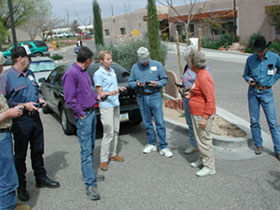
Together with Dr. Orr and other assistants from the Arid Lands program, I have presented several one- and two-day workshops across the state that have included participants from Yavapai County Cooperative Extension, the Yavapai Weed Management Area, the Tonto Basin Weed Management Area, Cochise/Graham/Greenlee County Cooperative Extension, Santa Cruz County Cooperative Extension, Yuma County Cooperative Extension, Bureau of Land Management, Audubon Appleton-Whittell Research Ranch, CDC-IMADES, The Nature Conservancy, US Fish & Wildlife Service, Gila County Roads Commission, and the Cochise/Graham/Greenlee County Master Watersheds Program. In addition, the materials I developed for these programs have been implemented in a variety of additional presentations in Arizona and outside of the state. Finally, I gave an invited seminar for the USDA Agricultural Research Service in Phoenix, AZ on GPS in April, 2003.

The most rewarding part of this experience has been that several of the groups have been taken enough by the technology to adopt it and integrate it into their everyday weeds management program. I have been invited back repeatedly to work with the Tonto Basin Weed Management Area and the Gila County Cooperative Extension groups. These groups have not only adopted the handheld computers and GPS technologies, but have been interested in working with the data in ArcView GIS on desktop computers. I am very encouraged by their enthusiasm, and am so happy to have played a role in their weed management efforts. My energy is now split between working with these groups and providing the assistance they presently need, and identifying ways that this program can be continued beyond my tenure as a UA/NASA Space Grant Fellow.

Natalie Dais Murray

Natalie Dais Murray, co-sponsored by the University of Arizona Department of Atmospheric Sciences

The best way to address the American public’s lack of the scientific understanding is by interacting directly with both students and teachers, particularly at the middle and high school levels. My educational outreach goal is to provide teachers with a solid knowledge base about weather and climate, along with supplementary materials. I have established a working relationship with the middle and high school science coordinators at Tucson Unified School District (TUSD). Last semester I conducted an intensive staff development workshop. Fourteen middle school teachers participated. The workshop covered basic topics in atmospheric science including: weather and climate, structure of the atmosphere, radiation, thunderstorms, tornadoes, lightning, hurricanes, as well as local weather events, such as the monsoon season. The class also visited the National Weather Service office located on the University of Arizona campus. During this hour tour and discussion, teachers were able to sit down with forecasters and learn how they do their jobs and ask any questions. I feel that this type of outreach is especially valuable because it educates teachers, who can then pass along the information to, not only current students but also to future students. The staff development class was needed especially after the adoption of the new FOSS weather and water instructional kit by TUSD. Only two of my teachers had taken an atmospheric science course in college yet they are required to provide ten weeks of instruction in this area. Another important aspect to my outreach is the development of a resource CD and information packet. These will contain copies of the materials presented in the workshop, along with links to websites with valuable and accurate information about weather and climate. The CD and information packet will provide much needed continuity for the project and will hopefully become a useful resource for the TUSD teachers.

The Space Grant Fellowship has helped both me and local teachers. I have great respect for people to teach middle school and high school. Their job is complex and taxing. These teachers spent some of their free time learning a subject to improve their ability to teach their students. This shows true dedication. I feel honored to be a part of that process and compelled to continue this type of work.